Drone de mission moyenne portée

Drone de mission à moyenne portée


SYSTÈME AÉRIEN DRONE à Moteur hybrid avec 8 hélices : injection électronique de carburant et réserve de batterie de 5 minutes de temps de vol.

1 hEUrE
AVEC 12lb (5.5 kg)

CapacitÉ DE CHARGE

100 km / 60 miles*

DISTANCE DE CONTRÔLE Video

5+ Heures

NON PAYLOAD MAX Flight Endurance

< 5 minutes

TEMPS D'INSTALLATION

LA RESERVE DE BATTERIE assurer la sécurité des charges utiles de grande valeur.

Le multirotor hybride le plus facile, le plus sûr et le plus endurant sur le marché

SPéCIFICATIONS

Maximum Speed36 mph (57 km/hr)
Cruise Ground Speed22 mph (35 km/hr)
Maximum Endurance *5+ hours without payload
2.5+ hours with 6.5 lb. (3 kg) payload
1+ hour with 11 lb. (5 kg) payload
Maximum Expected Range
(at cruise speed)
No Payload – 110 miles (177 km)
Maximum Tested Wind Speeds25 mph (35 km/hr)
Maximum Payload Capacity12 lb.+ (5.5 kg) payload with 2.2 lb (1 kg) fuel (1 hour).
Minimum Expected Temperature15°F (-10°C)
Maximum Expected Temperature122°F (50°C)
Size
Tip-to-Tip lengthArms removed: 2 feet x 2.66 feet (0.6 m x 0.81 m)
Ready to fly: 6.5 feet x 6.25 feet (2 m x 1.9 m)
Minimum Height14.5” (0.37 m)
HeightCustomizable to fit payload
Maximum Takeoff Weight42 lb (19 kg)
Controls and Communication
Radio FrequencyConfigurable. Contact us.
Maximum Expected Telemetry
Distance
6.2 miles (10 km)
Flight ModesManual through remote controller
– Stabilize
– Altitude (barometer- and GPS-based)
– Position (GPS-based)
GPS-based waypoint autonomy
– Survey
– Waypoint navigation and payload control
Automatic land and takeoff
Radio Telemetry Link EncryptionAES128 by default. Up to AES256.
Electronics, software and firmware
Autopilot FirmwareJanus Autopilot™. Proprietary. PX4-based.
Engine Control Firmware and
Electronics
Proprietary.
Autopilot ElectronicsProprietary. Pixhawk-based. Hardened and protected
Ground Control Station
Ground Control SoftwareJanus Ground Control Station™ (jGCS). Proprietary.
QGroundControl-based with engine telemetry and control.
Power System
SystemWindows 10 Laptop
Fuel DeliveryG2K proprietary hybrid gasoline-electric propulsion system
Ground Control HardwareElectronic Fuel Injection
Electrical Conversion Efficiency> 95%
Battery Flight Time5 minutes maximum at 42 lb (19 kg) takeoff weight.
(can increase by request)
Battery TypeLithium Polymer
Gasoline/Petrol Type91 Octane or above

* Flight times were measured at MSL 0’ in 50-75°F temperatures. Actual flight times depend on temperature, altitude,
wind and other environmental conditions.

** Tested operating conditions. Actual range may be greater.

Specifications are subject to change without notice.

CHOIX DES PAYLOADS

Sony UMC-R10C
Visuel et Thermique
  • 720p HD Digital Video
  • Electronic Stabilization and Scene Tracking
  • 30X Zoom
  • Laser Pointer
  • Environmentally sealed
  • Uses: ISR
  • Durée de vol de 3 heures
Phoenix LiDAR AL3-32 LiDAR
LiDAR
  • Visualization and processing software
  • Based on Velodyne HDL-32 sensor
  • Utilisations: Surveillance, Cartographie
  • Durée de vol de 2 heures / 300 acres
Sony A6500 Visual
Visuel
  • APS-C Exmor sensor
  • 24.2 MP
  • 5-Axis in-body stabilization
  • 11 frames per second continuous shooting
  • 4K movie with 2.4X oversampling
  • Utilisations: ISR, Inspection, Mapping
  • Durée de vol de 3 heures
MagArrow-Side-Angle-NEW-300x118
Geometrics MagArrow
Magnetometrie
  • 1 nanotesla sensitivity
  • No data drop outs
  • Works in all orientations
  • Integrated IMU and GPS
  • Utilisations:  Unexploded Ordinance / Wellhead Detection, Resource exploration
  • Durée de vol de 3-4 heures
MicaSense RedEdge
Multispectre
  • Five narrow bands 12 bit sensors
  • 8cm/pixel at 400ft
  • Utilisations: Agriculture
  • Durée de vol de 4 heures 30
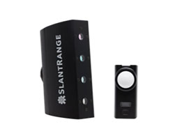
Slantrange 3P
Multispectre
  • Instant results in field. No network required.
  • Complete software suite for stitching and analyzing photos.
  • 4 Spectral Channels. 4.8 cm / pixel at 400 ft AGL
  • 4X area coverage, requiring minimal overlap
  • Utilisations: Agriculture
  • 2000 acres en 4.5 heures à  26 mph @ 400 ft AGL
UKRSPEC USG-302
Visuel and Thermique
  • Full HD 1080p video with 30x zoom
  • 640 x 480, 9 GHz thermal imaging
  • Gyro-stabilized gimbal
  • Utilisations: ISR
  • Durée de vol de 2 heures 30
Routescene LidarPod
LiDAR
  • Système de Cartographie clés en main
  • Visualisation, quality assurance, and post processing software
  • Based on Velodyne HDL-32 sensor
  • 700,000 points par seconde
  • Dual returns
  • Infra-red 905 nm wavelength
  • Utilisations: Surveillance, Cartographie
  • Durée de vol de de 2 heures hour / 300 acres
FLIR Duo Pro R
Visuel and Thermique
  • 4000 x 3000 visible sensor
  • 640 x 512, 30Hz thermal imaging
  • Gremsy T1 Gimbal
  • Radiometrie/mesure de temperature
  • Utilisations: Inspection, ISR
  • Durée de vol de 4 heures
Sony UMC-R10C Visual
  • APS-C size sensor
  • 20 MP still image
  • Utilisations: Cartographie
  • Durée de vol de 4 heures
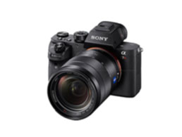
Sony A7R MKIII
Visuel
  • Exmor R CMOS sensor
  • 42 MP image processor
  • Full-frame mirrorless camera
  • 8 frames par seconde shooting continue
  • Utilisations: ISR, Inspection, Cartographie
  • Durée de vol de 3 heures
Pour toutes demandes, envoyez nous un email à

INFO@SAFESKYDRONE.COM